


One of the most fascinating mysteries in human history is the so-called Nazca Lines, which, despite countless attempts at interpretation, still retain their age-old secret. Who created the lines? What were they used for? How was it possible to construct such precise formations without viewing them from the air? These questions remain unanswered.
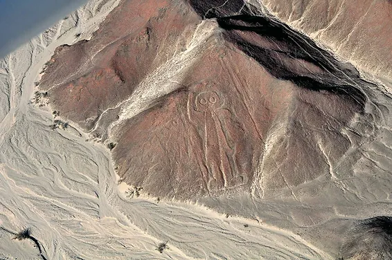
But where are the Nazca geoglyphs found? They are located in southern Peru, where more than 13,000 lines form around 800 figures, most of them depicting stylized animals. Perhaps the most intriguing aspect is their enormous scale. The geoglyphs are almost impossible to appreciate from ground level.
The figures were not discovered until 1927, when the archaeologist Toribio Mejía Xesspe first identified them while surveying the area. As aviation later became more common, their full extent was revealed from the air.
Over the years, numerous theories have been proposed in an attempt to solve the mystery. Author Erich von Däniken argued that the lines were created in anticipation of the gods’ return to Earth, while other, more speculative theories suggest they served as guides for visitors from the sky. There are, however, more conventional archaeological explanations as well.


Different theories
According to archaeologist Maria Reiche, the lines had a clear astronomical significance. She believed that each figure was aligned with a particular constellation at the time it was created. For example, she argued that the Monkey figure was associated with Ursa Major, while the Dolphin and the Spider corresponded to the constellation Orion.
David Johnson, an independent American researcher who collaborated with the University of Massachusetts, revived a theory put forward by archaeologists Markus Reindel and Johny Isla. Their hypothesis suggests a strong connection between the presence of water in the region and the Nazca geoglyphs—a theory that could help solve the mystery of the Peruvian desert. According to this view, the pre-Hispanic inhabitants were familiar with the underground aquifers that were replenished by water flowing from the surrounding mountains.

According to Johnson, the geoglyphs formed an enormous map of underground water resources. This interpretation is also supported by researchers at the German Archaeological Institute and the Andean Institute for Archaeological Research, where Markus Reindel and Johny Isla have conducted extensive work.
Researchers have discovered and documented ritual offerings placed in small pits near the geoglyphs. These are believed to have been offerings to the gods in gratitude for the presence of water at those locations. According to Johnson, the lines therefore served as an extraordinary map of the region’s water resources.
”It is highly likely,” Johnson explains, ”that the lines were a kind of message used to indicate where water could be found, whether in springs or underground aquifers.”
For example, encountering a geometric figure may have indicated that a water source was nearby. Circles are thought to have been drawn close to wells and springs, as were many of the large animal figures. The hummingbird—one of the most beautiful figures among the Nazca Lines—appears to point with its beak toward a major water source.
However, although Johnson’s theory is compelling, it does not fully explain the mystery, nor can it account for every figure. One of the most remarkable geoglyphs at Nazca is the Spider, which represents one of the site’s greatest enigmas. Entomologists have identified it as belonging to the order Ricinulei, one of the world’s rarest groups of arachnids. These creatures are found only in remote areas of the Amazon rainforest.
The geoglyph is so detailed that it depicts the spider with the characteristic reproductive organ located at the tip of one extended leg—a fertilization mechanism that is normally visible only under a microscope.
This challenges the water theory and raises the possibility that the Nazca people possessed knowledge far more advanced than we currently assume.
Moreover, the method by which the geoglyphs were constructed remains an unsolved mystery. The lines do not extend merely a few meters—they stretch for kilometers. Some are as long as 8 kilometers, while others extend up to 65 kilometers. They are also best appreciated from the air.
This raises an obvious question: did the Nazca people somehow need an aerial perspective to use these lines for locating water? And if they marked water sources, why would they also align them with astronomical constellations?
For now, we will likely have to wait for new archaeological discoveries before these questions can be answered.


